Trying to research on this subject since a lot of inventions first took place in China. A reference to a map can be found in the Volume 86 of the historical text Records of the Grand Historian (Shi Ji) (Wiki). This volume recorded an incident in 227 BC during the late Warring States period in which a map is mentioned. Even earlier references and indications of use of maps could be found in following records:
- Book of Documents (Shu-ching) tells that a survey of a particular region had been made to decide on the most suitable place for a new capital. The Book is estimated to be works of the 4th century b.c and maybe earlier (Britannica).
- Sun Tzu (544-496 b.c.) in his Art of War remarks that the measurement of space has to be derived from the ground”‘ suggest that the design of maps depended on actual surveys of the land (Expedition).
- The Kuan-tzu (an ancient document attributed to the 7th century BCE philosopher and statesman Guan Zhong) is reported to contain fragments of a chapter on maps stressing their importance for the conduct of war.
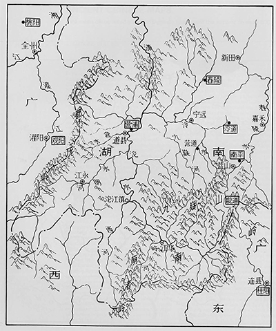
Wilford mentions two silk maps discovered in the tomb of a prime minister’s son from the second century b.c. These two maps are the earliest physical finds. Finds are described as highly accurate works painted on silk, both adhering to Chinese ancient cosmological views, south is above and north below.
The information on the map includes topographical features with names of counties, mountains, rivers, residential areas etc. The legends are standardized with the names of counties placed in squares, residential names in circles, names of tributary rivers written near their confluence with larger rivers, and so on (Expedition). See first map here, and parts of map 2 here.