• Home
  • Cartographic Portfolio
  • Posts
  • Resources
    • Main ESRI Resources
    • Conversion Tools
    • Coordinate Systems
    • Interesting
  • Contact
Baseline GIS

Baseline GIS

Personal notes on day-to-day GIS tasks, and general observations related to GIS

Showing all posts tagged history

In Historical

Early Maps – Bedolina Petroglyph and Babylonian World Map

Author admin1135Posted on October 2, 2021April 22, 2022
Early Maps – Bedolina Petroglyph and Babylonian World Map

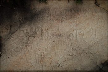
Quick description of two early maps: Petroglyph rock – Bedolina map dated to c.1500 BC, and Babylonian clay tablet dated to 6th century BC.

Tags: history

Search Archives

Recent Posts

  • Customizing layout templates gallery January 18, 2023
  • Creating quarter sections in ArcPro December 6, 2022
  • BIM & GIS Integration Resources October 2, 2022
  • Creating GUIDs in ArcPro July 30, 2022
  • Clipping rasters to a shapefile and merging into one image June 21, 2022

RSS GIS Lounge

  • New Techniques for Measuring Biodiversity With Remote Sensing January 23, 2023
    New satellite imagery techniques make it easier to observe plant biodiversity and map changes over time, allowing conservationists to plan for the future. The post New Techniques for Measuring Biodiversity With Remote Sensing appeared first on GIS Lounge.
    Mark Altaweel
  • Improving the Accuracy of GPS and GNSS January 2, 2023
    To improve accuracy and signaling of GPS and GNSS, a new technique that depends on ground-based systems has been developed. The post Improving the Accuracy of GPS and GNSS appeared first on GIS Lounge.
    Mark Altaweel
  • Mapping Coastal Ecosystem Change December 21, 2022
    A new collaboration initiative, called coastTrain, helps to provide data so that scientists can better address challenges coastal regions face. The post Mapping Coastal Ecosystem Change appeared first on GIS Lounge.
    Mark Altaweel
© 2023 Baseline GIS
Theme by justgoodthemes.com. Back to the top