• Home
  • Cartographic Portfolio
  • Posts
  • Resources
    • Main ESRI Resources
    • Conversion Tools
    • Coordinate Systems
    • Interesting
  • Contact
Baseline GIS

Baseline GIS

Personal notes on day-to-day GIS tasks, and general observations related to GIS

Showing all posts in GIS User Notes

In ArcPro, GIS User Notes, Uncategorized

Geocoding

Author admin1135Posted on June 5, 2024June 5, 2024

Quick reminder notes on how to run geocoding using ArcPro

In ArcPro

ARCADE Expressions Notes

Author admin1135Posted on October 24, 2023January 25, 2024

Arcade expressions to style labels in ArcPro

Tags: ArcPro
In ArcPro, ESRI Products

Manage Symbology Templates

Author admin1135Posted on October 18, 2023

Forget how to pull up Feature Templates? This is a quick how-to with pictures.

Tags: ArcPro
In Survey123

Customizing layout templates gallery

Author admin1135Posted on January 18, 2023January 18, 2023

Quick notes on how to make a custom layouts gallery

Tags: survey123
In ArcPro

Creating quarter sections in ArcPro

Author admin1135Posted on December 6, 2022
Creating quarter sections in ArcPro

This is a very basic exercised in splitting PLSS sections into quarter parts using “Subdivide Polygon” tool in Arcpro.

Tags: ArcPro
In AutoCAD, ESRI Products

BIM & GIS Integration Resources

Author admin1135Posted on October 2, 2022

Online resources dedicated to BIM & GIS integration

Tags: BIM
In ArcPro, Enterprise GIS

Creating GUIDs in ArcPro

Author admin1135Posted on July 30, 2022July 30, 2022

Basic summary of differences between GUIDs and GlobalIDs and when to use which one in GIS

Tags: ArcPro, Enterprise GIS, GlobalID, GUID
In ArcPro, Imagery

Clipping rasters to a shapefile and merging into one image

Author admin1135Posted on June 21, 2022June 21, 2022
Clipping rasters to a shapefile and merging into one image

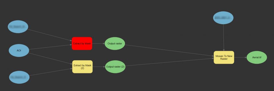
Very simple yet often needing a reminder process of extracting raster(s) to an irregular shape, and merging several images into one.

Tags: imagery, raster
In GIS Apps, QuickCapture

Exploring Quick Capture for the First Time

Author admin1135Posted on April 23, 2022June 2, 2022
Exploring Quick Capture for the First Time

First time playing around with QuickCapture mobile application. Initial basic notes and references.

Tags: mobile application, QuickCapture.
In GIS Apps, Survey123

Survey123 Connect using SDE layers

Author admin1135Posted on April 14, 2022January 18, 2023

Notes taken while launching Survey123 against an SDE feature for the first time. This method is great for monitoring and inspections of existing features , or facilities, as an example. This is a first effort of more advanced use of Survey123 Connect, with additional posts hopefully to follow.

Tags: mobile application, survey123

Posts navigation

Page 1 Page 2 … Page 4 Next

Search Archives

Recent Posts

  • Geocoding June 5, 2024
  • ARCADE Expressions Notes October 24, 2023
  • Manage Symbology Templates October 18, 2023
  • Customizing layout templates gallery January 18, 2023
  • Creating quarter sections in ArcPro December 6, 2022

RSS GIS Lounge

  • Rivers that Flow Backwards June 13, 2025
    Read about how the Amazon once flowed east to west and how the strength of Hurricane Isaac once change the course of the Mississippi river. The post Rivers that Flow Backwards appeared first on Geography Realm.
    Caitlin Dempsey
  • Northernmost Point in the United States May 28, 2025
    Above the Arctic Circle, Point Barrow is the northernmost point in the United States. The post Northernmost Point in the United States appeared first on Geography Realm.
    Caitlin Dempsey
  • How to Create a Radial Flow Map Using QGIS May 26, 2025
    Learn how to create a radial flow map in QGIS to visualize migration using metro-to-metro data from the U.S. Census Bureau. The post How to Create a Radial Flow Map Using QGIS appeared first on Geography Realm.
    Caitlin Dempsey
© 2025 Baseline GIS
Theme by justgoodthemes.com. Back to the top