Quick reminder notes on how to run geocoding using ArcPro
Showing all posts in ArcPro
ARCADE Expressions Notes
Arcade expressions to style labels in ArcPro
Manage Symbology Templates
Forget how to pull up Feature Templates? This is a quick how-to with pictures.
Creating quarter sections in ArcPro
This is a very basic exercised in splitting PLSS sections into quarter parts using “Subdivide Polygon” tool in Arcpro.
Creating GUIDs in ArcPro
Basic summary of differences between GUIDs and GlobalIDs and when to use which one in GIS
Clipping rasters to a shapefile and merging into one image
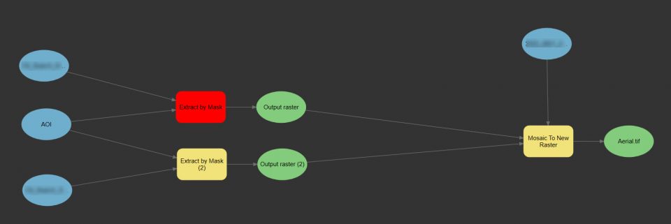
Very simple yet often needing a reminder process of extracting raster(s) to an irregular shape, and merging several images into one.
Creating Elevation Rasters from XYZ Data
Never was DEM creation that straightforward in ArcGIS as it is in Global Mapper. And in both cases processing the data should be done carefully as to preserve elevation information in the new raster as accurate as possible. I will try to review available options. First of all, I would avoid Interpolations tools in the … Read More
Adding Mapbox imagery into ArcPro Project
Current version of ArcPro 2.8.3. If there is never enough of a base imagery, it is possible to integrate basemaps from Mapbox gallery, as I just learned. Original credit goes to this users: This article provide quick updates as I noticed that the interface in the Mapbox slightly has changed since the video was made. … Read More
Deploying ArcGIS Maps for Adobe Creative Cloud

This is one of those cool integrations that ESRI has been working on for some time now. Maps exported from ArcPro could be exported in .aix format. AIX stands for Adobe Illustrator Exchange. More here – Use .aix files from ArcGIS Pro—ArcGIS Maps for Adobe Creative Cloud | Documentation. Here is a forum discussion dedicated … Read More
Customizing ArcPro Default Settings
Quick notes when migrating to ArcPro with existing GIS infrastructure in place within an Organization