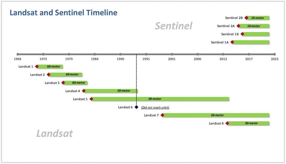
• Home
  • Cartographic Portfolio
  • Posts
  • Resources
    • Main ESRI Resources
    • Conversion Tools
    • Coordinate Systems
    • Interesting
  • Contact
Baseline GIS

Baseline GIS

Personal notes on day-to-day GIS tasks, and general observations related to GIS

Showing all posts tagged landsat

In Imagery

Satellites Timeline

Author admin1135Posted on August 11, 2021June 21, 2022
Satellites Timeline

Notes on chronology of satellite programs

Tags: imagery, landsat, raster, sentinel

Search Archives

Recent Posts

  • Customizing layout templates gallery January 18, 2023
  • Creating quarter sections in ArcPro December 6, 2022
  • BIM & GIS Integration Resources October 2, 2022
  • Creating GUIDs in ArcPro July 30, 2022
  • Clipping rasters to a shapefile and merging into one image June 21, 2022

RSS GIS Lounge

  • Dissolve Features Based on Attribute in QGIS March 19, 2023
    This GIS tutorial provides a step-by-step guide on how to dissolve features in QGIS based on an attribute field. The post Dissolve Features Based on Attribute in QGIS appeared first on GIS Lounge.
    Caitlin Dempsey
  • GIS for Local Government: Public Safety March 15, 2023
    This GIS tutorial from Maptitude shows users how to map out crime and demographics. The post GIS for Local Government: Public Safety appeared first on GIS Lounge.
    Maptitude
  • United States Cropland Data March 11, 2023
    The Cropland Data Layer (CDL) is an annually updated GIS dataset developed by the USDA that maps out crops grown in the United States. The post United States Cropland Data appeared first on GIS Lounge.
    Caitlin Dempsey
© 2023 Baseline GIS
Theme by justgoodthemes.com. Back to the top