General list of supported raster formats with links to more detailed sources
Showing all posts by admin1135
Customizing ArcPro Default Settings
Quick notes when migrating to ArcPro with existing GIS infrastructure in place within an Organization
Working with Map Series in ArcPro
Notes on how to setup map series in ArcPro
List of ESRI training for professional development
Enterprise Management ArcGIS Enterprise: Installation Fundamentals | Learning Plan (esri.com) – Learning Plan 5 courses: ArcGIS Enterprise: An Introduction | Esri Training Video – Requires Maintenance, 38 minutes ArcGIS Enterprise: Architecting Your Deployment | Esri Training Video – Free, 68 minutes ArcGIS Enterprise: Configuring a Base Deployment | Esri Training Instructor-Led Course – cost $1,500, … Read More
Recommended Online Classes for Absolute Beginners in GIS

This is a question very frequently asked on social platforms – How do I start in GIS? Where should I start? My personal answer would always be – start with the foundational basics. Below are online modules that I personally selected as appropriate for absolute beginners. Modules are listed in escalating order from basic to … Read More
Satellites Timeline
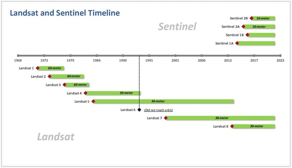
Notes on chronology of satellite programs
Searching for Sentinel imagery
Satellite imagery is a powerful tool for any industry. Sentinel imagery is relatively recent program, with images produced at a higher resolution. Have you tried looking up available imagery? Here are four ways to do so….
Adding relational table to online feature layer
Notes taken after publishing complex related table into Portal/AGO for the first time.
3D in ArcPro – Scene
Rasters There is enough material written about difference in Local Scene versus Global Scene (Choose global or local—ArcGIS Online Help | Documentation). Here I will be using Local Scene as I am in a particular area. The new Local Scene just got create with default layers in the table of contents: 3D layers – that … Read More
ArcGIS Enterprise – References for Deployment
Collection of resources related to Enterprise GIS deployment